+855 12706595
info@nurahmantour.com


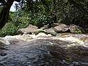
Kampot (Khmer: កំពត [kɑmpɔːt], lit. ‘The Kampot’s Fish‘) is a province in southwestern Cambodia. It borders the provinces of Koh Kong and Kampong Speu to the north, Takéo to the east, Kep and the country of Vietnam (Kiên Giang) to the south, and Sihanoukville to the west. To its south, it has a coastline of around 45 km on the Gulf of Thailand. It is rich in low arable lands and has abundant natural resources. Its capital is the city of Kampot.
Kampot Province had a population of 627,884 in 2010, and eight districts were divided into 92 communes with 477 villages. Touk Meas City is located in the province.
|
Kampot
កំពត
|
|
|---|---|
|
Province
|
|
| Kampot Province ខេត្តកំពត |
|
    |
|
|
Seal
|
|
|
Map of Cambodia highlighting Kampot
|
|
| Coordinates: 10°36′N 104°10′E | |
| Country | |
| Provincial status | 20 August 1923 |
| Capital | Kampot |
|
Government |
|
| • Governor | Mao Thonin (CPP) |
| • National Assembly |
6 / 125 |
|
Area |
|
| • Total | 4,873 km2 (1,881 sq mi) |
| • Rank | Ranked 17th |
|
Population (2023)
|
|
| • Total | |
| • Rank | 12th |
| • Density | 143/km2 (370/sq mi) |
| • Rank | 12th |
| Time zone | UTC+7 (ICT) |
| Dialing code | +855 |
| ISO 3166 code | KH-7 |
| Districts | 8 |
| Communes | 93 |
| Villages | 488 |
| Website | kampot |
In the 19th century, during the French Indochina period, Kampot became a regional administrative center with the status of a state border district due to the delimitation of the Kingdom of Cambodia. The Circonscription Résidentielle de Kampot contained the arrondissements of Kampot, Kompong-Som, Trang and Kong-Pisey.
In 1889, the French colonial census reported a multi-ethnic community: Kampot town consisted of “Cambodian Kampot” on the Prek-Kampot River and “Chinese Kampot” on the right riverbank of the west branch of the Prek-Thom River. Nearby was also a Vietnamese village, called Tien-Thanh and another Vietnamese village on Traeuy Koh Island. A Malay also existed on Traeuy Koh Island. Additional villages of mixed ethnicity are listed.
Destruction and mass murder happened throughout the whole area of Kampot province, as the Cambodian genocide and bloody massacres engulfed Kampot province under the terror of Khmer Rouge rule. A total of 90,450 persons were massacred throughout the province. Ta Mok himself massacred 30,000 people in the Angkor Chey District of Kampot.
Agriculture
Forestry and Mining
Tourism
The province is subdivided into 7 districts and 1 municipality.
| ISO code | District | Khmer | Population (2019)] |
|---|---|---|---|
| 07-01 | Angkor Chey | ស្រុកអង្គរជ័យ | 88,263 |
| 07-02 | Banteay Meas | ស្រុកបន្ទាយមាស | 100,299 |
| 07-03 | Chhouk | ស្រុកឈូក | 125,406 |
| 07-04 | Chum Kiri | ស្រុកជុំគិរី | 56,784 |
| 07-05 | Dang Tong | ស្រុកដងទង់ | 63,911 |
| 07-06 | Kampong Trach | ស្រុកកំពង់ត្រាច | 98,683 |
| 07-07 | Tuek Chhou | ស្រុកទឹកឈូ | 126,789 |
| 07-08 | Kampot Municipality | ក្រុងកំពត | 38,950 |


